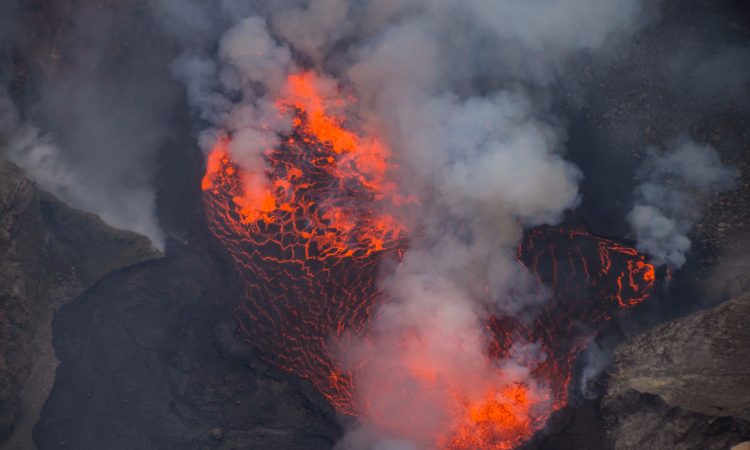
Mount Nyiragongo stands at 3,470 meters above sea level. It is one of the Virunga Mountains located along the Albertine Rift. At its summit is a wide crater about 2 kilometers across. Inside it lies a large lava lake, known to be one of the biggest in the world.
The lava lake has reached a height of 3,250 meters and a depth of 600 meters. Around the volcano are small volcanic cones formed from side eruptions.
Mount Nyiragongo has erupted at least 32 times since 1882. Its history is not fully known because of political problems in Congo. The lava is the fastest in the world, flowing up to 97 kilometers per hour.
In 1977, a sudden eruption killed around 300 people in just 20 minutes. The most recent major eruption happened on January 17, 2002. Lava flowed in three directions, spreading smoke and ash into the sky.
Mount Nyiragongo has the world’s largest lava lake and is one of the most active volcanoes. Hiking to the top is a special experience. The hike starts about 30 minutes by car from Goma. Visitors are guided by trained rangers.
Other Virunga volcanoes include Mount Bisoke, Mount Karisimbi, Mount Muhabura, Mount Gahinga, Mount Sabyinyo, Mount Nyamuragira, and Mount Mikeno.
Hiking Mount Nyiragongo
Mount Nyiragongo is shared between Congo, Uganda, and Rwanda. It partly overlaps with two other volcanoes, Shaheru and Baratu. The lava lake is considered the biggest in recent times.
Before the 1977 eruption, the lake stood at 3,250 meters. After the 2002 eruption, it reached 600 meters deep. Small cones around the volcano were formed during earlier side eruptions.
The volcano is monitored from the Goma Volcanic Observatory. Scientists collect data every few minutes. Sadly, the World Bank stopped funding the center in 2020.
Because the mountain lies on a very active part of the African Rift, magma rises from below the earth. Signs of magma have also been found under nearby Lake Kivu.
About 100 small cones are located south of Shaheru and extend to Lake Kivu and east of the volcano.
Location & Access
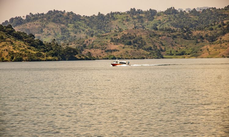
Mount Nyiragongo is in the Virunga Conservation Area, inside Virunga National Park, Democratic Republic of Congo. It is 12 kilometers north of Goma and Lake Kivu.
The best way to visit is by flying into Kigali International Airport in Rwanda, then driving to the border through Gisenyi to reach the park.
Nyiragongo Entry Fees & Permits
Visitors must pay entry fees. A hiking permit costs $300 and includes overnight stay at the summit and park entry. This fee does not include meals or porters.
An extra $100 provides a backpack, meals, water, sleeping bag, blanket, fleece, and jacket. Porters charge $25 for every 15 kilograms of luggage.
Permits must be booked in advance through a tour company or directly with the park. Hikes begin in the morning at Kibati Ranger Post with a short briefing.
The climb has five phases:
- Lower altitude path
- Rocky lava areas
- Tougher climbs at higher points
- Steeper ascent
- Short but steep final climb
At the top are 12 cabins with 2 beds each, mattresses, and pillows. The next morning, visitors enjoy the view of the lava lake before descending, which takes about 3 hours.
Hiking Essentials
- Visitors should come prepared with:
- Hiking boots and gloves
- Flashlight and extra batteries
- Water and snacks
- Warm clothes and rain jacket
- Sunscreen and insect repellent
- Hat, sunglasses, binoculars, camera
- Power bank for charging devices
History of Eruptions
The lava lake was first confirmed in 1948. It covered about 120,000 square meters. Since then, its size, temperature, and depth have changed many times.
The volcano was not studied for years because of civil war in Congo. Since 1882, it has erupted about 34 times.
From 1894 to 1977, it had an active lava lake. On January 10, 1977, the crater wall broke, and lava flowed at 60 km/h. About 600 people died. The lava flowed in all directions except east.
In 1991, the mountain was marked as a “decade volcano” for study. A new small volcano, Murara, formed near Mount Nyamuragira.
From 1982 to 1994, the lava lake reappeared. In January 2002, a 13-kilometer fissure opened, and lava reached Lake Kivu and parts of Goma. Lava flows were 2 meters deep and up to 1,000 meters wide.
Over 400,000 people had already left Goma and moved to Gisenyi in Rwanda. Lava covered 13% of Goma. There were fears of a gas release from Lake Kivu, but it did not happen. Scientists continue to monitor the area.
Six months later, the volcano erupted again. About 200 people died, and over 120,000 were left homeless. Earthquakes continued to affect Goma and Gisenyi.
In 2016, scientists found a new vent at the crater’s northeast edge. This may lead to a side eruption in the future.
2021 Eruption and Death Toll
On May 22, 2021, Mount Nyiragongo erupted again. Lava cut off a road to Beni and moved toward eastern Goma. Many people fled the area. About 32 people died; 24 from lava burns, 5 from gas, and 3 during evacuation.
In total:
- 600 people died in 1977
- 245 people died in 2002
- 32 people died in 2021
Also, 40 adults and 540 children went missing in 2021. Gas known as Mazuka has killed several children. Scientists are concerned about the long-term effects of eruptions.
Best Time to Visit
Mount Nyiragongo can be visited any time, but the best months are December to February and June to August. These are the dry seasons. Trails are easier to climb, and the skies are clear for better views and photos.
Where to Stay
At the summit, only one place offers accommodation; Nyiragongo Summit Shelter, with 12 cabins, each with 2 beds, mattresses, and pillows.
Other nearby options before or after hiking include Mikeno Lodge, Bukima Tented Camp, Kibumba Tented Camp, Lulimbi Tented Camp, Ngila Lodge, Tchegera Island Tented Camp, and Lac Kivu Hotel.